
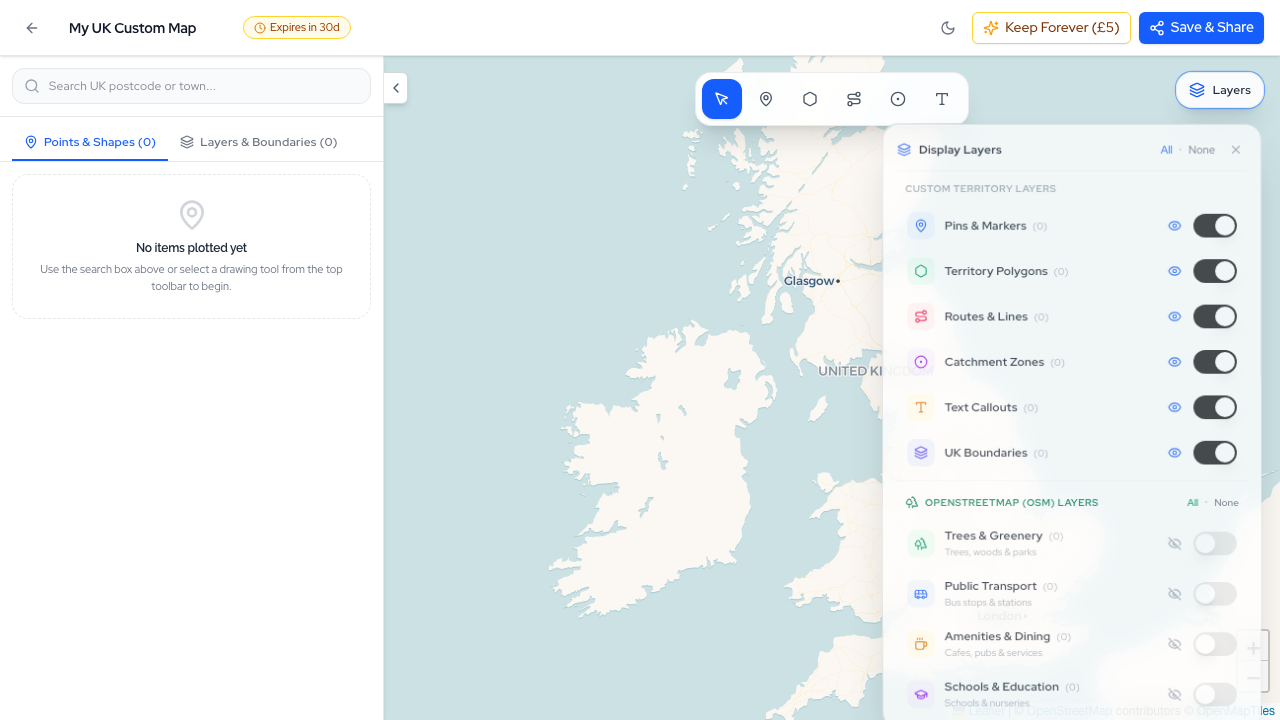
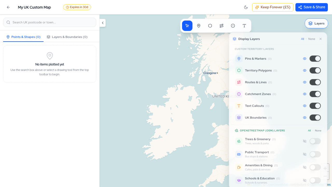
Map Studio layer controls, live territory polygon calculations, and authoritative vector styling introduced across our summer release cycle.
Over the last eight weeks, the Postcodewise engineering team has shipped over 35 production releases (spanning v2.13.0 through v2.49.12). What began as a focused initiative to eliminate third-party API latency has blossomed into a full-scale evolution of our entire location-intelligence stack.
From visual geospatial authoring in Map Studio to sub-10ms autocomplete via Typesense SearchSense, authoritative NaPTAN transit networks, multi-turn Conversational AI, and our official Model Context Protocol (MCP) server for AI agents—every corner of Postcodewise has been re-architected.
Here is an exhaustive guide to everything we have launched, why it matters, and how you can take advantage of these new capabilities today.
At a Glance: Two Months of Relentless Velocity
Before diving into each system, here is a high-level overview of the major platform milestones delivered between July and September 2026:
| Release Range | Primary Milestone | Core Impact |
|---|---|---|
| v2.48 – v2.49 | Map Studio & Shareable Maps | 3D building extrusions, live territory area & perimeter geometry, custom boundary styles, RFC 7946 GeoJSON exports, and permanent upgrades. |
| v2.46 – v2.47 | Authoritative NaPTAN Transit | Full Department for Transport NaPTAN dataset ingestion, OSGB36 coordinate recovery, algorithmic hub clustering, zero synthetic bus routes. |
| v2.44 – v2.45 | FSA Food Hygiene & Premises | Live Food Standards Agency inspection scoring and commercial premises intelligence integrated into catchment reports. |
| v2.42 – v2.43 | Deprivation & UPRN Linking | Versioned LSOA geography for English Indices of Multiple Deprivation (IMD) and PAF Unique Property Reference Number matching. |
| v2.40 – v2.41 | Conversational Location AI | In-hero natural language questions, persistent slide-over Assist Drawer, local government data grounding with zero hallucinations. |
| v2.38 – v2.39 | Audience Lenses | 4 tailored analytical perspectives (Buyers, Investors, Commercial, Surveyors) across Postcodes, Districts, Wards, and Comparisons. |
| v2.36 – v2.37 | Deep Due Diligence & Hazards | Defra strategic noise contours (Road, Rail, Aviation), BGS ground subsidence/radon hazards, and hyper-local gross rental yields. |
| v2.34 – v2.35 | GLA Planning & Outcodes | GLA Planning London Datahub feed, universal 300+ UK council planning portal resolver, and district outcode reports (/outcode/*). |
| v2.30 – v2.31 | Typesense SearchSense | Sub-10ms autocomplete across 1.8M postcodes, Postel's Law input flexibility, and anchored dropdown UX replacing modal overlays. |
| v2.27 – v2.28 | Model Context Protocol (MCP) | Anthropic MCP server integration enabling Claude Desktop, Cursor, and autonomous agents to query Postcodewise directly. |
| v2.13 – v2.26 | Security & Speed Foundations | Fortify 2FA, Passkeys, strict UK phone verification, local Defra PCM air quality, and complete elimination of live Overpass API bottlenecks. |
1. Map Studio & Shareable Custom Maps (v2.48 – v2.49)
Location intelligence often requires active visual authoring rather than passive reading. Planners need to sketch delivery catchments, investors need to demarcate target development zones, and community organizers need to examine political boundary intersections.
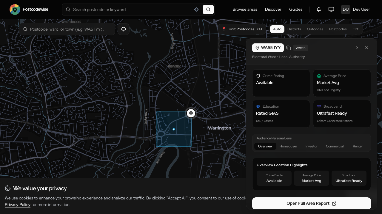
With Map Studio, we have introduced an interactive, professional-grade vector map builder directly in Postcodewise:
Live Territory Measurements
As you draw territory polygons on the vector canvas, our geospatial math engine computes real-time geometric dimensions:
- Area: Metric (km², hectares) and Imperial (acres, sq miles) measurements calculated dynamically.
- Perimeter: Running boundary distance updated on every vertex drag.
- Bounding Box (Bbox): Precise latitude/longitude bounding extents calculated for viewport fitting and export.
Layer Visibility & Basemap Customization
Map Studio features an intelligent layer controller allowing users to toggle individual elements independently:
- Custom Territory Layers: Pins & markers, territory polygons, travel routes & lines, catchment buffer zones, and custom text callouts.
- OpenStreetMap Detail Layers: High-resolution trees & greenery, public transport stops, dining & commercial amenities, and schools.
- UK Administrative & Election Boundaries: UK Parliamentary Constituencies, Electoral Wards, and Postal Districts rendered with crisp vector outlines.
- Complete Style Freedom: Set custom fill hex codes, adjust opacity sliders, modify stroke widths, and switch between Light, Dark, Outdoors, and OSM Detail basemaps.
RFC 7946 Compliant GeoJSON Export
Every custom map can be exported directly as a validated RFC 7946 GeoJSON FeatureCollection. This allows GIS analysts, surveyors, and developers to take custom boundaries created in Map Studio directly into QGIS, ArcGIS, or custom Mapbox applications without conversion friction.
Shareable Map Links & Permanent Upgrades
Every map generated in Map Studio receives a secure, shareable public link with a default 30-day retention window. Users who need permanent hosting for public documentation or client deliverables can upgrade individual maps permanently for a single flat fee of £5.
2. Authoritative NaPTAN Transport Intelligence (v2.46 – v2.49 / T15)
Public transport connectivity is one of the most significant determinants of property value, rental yield, and commercial footfall. However, many property websites rely on synthetic transit estimates or sparse Overpass queries that miss local bus networks or merge distinct transit nodes.
In Milestone T15, we executed a ground-up rebuild of our transport intelligence engine:
Direct Ingestion of the Official NaPTAN Dataset
We now ingest the complete National Public Transport Access Nodes (NaPTAN) repository directly from the Department for Transport (DfT). Covering every registered railway station, metro terminal, ferry port, and bus stop across England, Scotland, and Wales, NaPTAN represents the gold standard of UK transit data.
High-Precision Coordinate Recovery
Official UK transit nodes are frequently published using British National Grid coordinates (OSGB36 Easting and Northing). Our automated data pipeline performs mathematical coordinate transformation to WGS84 latitude and longitude with millimetre accuracy, ensuring bus stop markers and station entrances align perfectly with road centerlines.
Algorithmic Hub Clustering (Name + Mode + Locality)
To solve the industry-wide problem where bus stops serving opposite sides of a dual carriageway or adjacent village greens get improperly merged into synthetic "mega-hubs", we engineered an algorithmic clustering pipeline. Nodes are clustered strictly by matching Stop Name, Transit Mode (Bus, Rail, Metro), and Locality Code, preserving true walking distances.
Strict "Zero Synthetic Data" Policy
We do not simulate, invent, or guess transit schedules or bus routes. Every transport score, walkability index, and nearest-station distance is calculated from verified, physical NaPTAN nodes and statutory timetable registries.
3. Conversational Location Intelligence & The Assist Drawer (v2.40 – v2.41)
Finding the right neighbourhood has traditionally required juggling 20 tabs across Rightmove, police crime portals, council websites, and school league tables. Users were forced to perform mental arithmetic on raw data points.
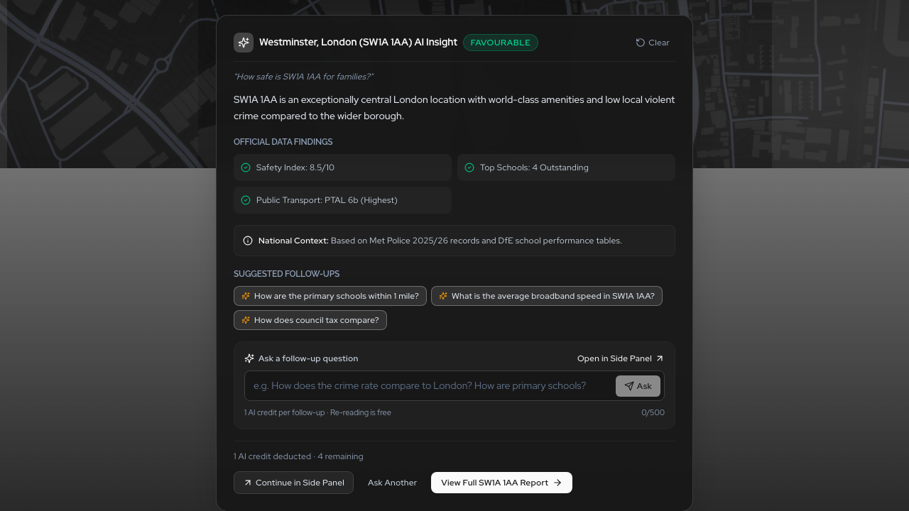
In v2.41, we launched Conversational Location Intelligence—allowing anyone to explore UK postcodes using natural human conversation:
Multi-Turn Natural Language Ingestion
Instead of navigating rigid forms, you can ask open-ended, multifaceted questions directly in our search hero:
- "Which areas near Bristol Temple Meads offer good primary schools and low burglary rates for under £450k?"
- "Compare the demographic stability and rental yield profile between Leeds LS1 and Headingley LS6."
- "Are there any active commercial planning applications or high noise levels affecting this high street?"
The Persistent Slide-Over Assist Drawer
Location research is inherently spatial. When engaging in a multi-turn conversation, you should never lose sight of the interactive map, school boundaries, or crime charts.
The Assist Drawer slides smoothly out from the right edge of the viewport, maintaining your full visual session context while allowing you to probe deeper with follow-up questions.

Strict Local Grounding: Zero LLM Hallucinations
Generic LLMs are notorious for fabricating local trivia—inventing fictional crime statistics or misquoting Ofsted grades. Our conversational engine utilizes a strict local grounding architecture:
- Natural language inputs are parsed into structured database queries across our local repository.
- Verified records from the DfE, Police.uk, ONS, Defra, and BGS are retrieved in sub-second time.
- The language model synthesizes the verified facts into an authoritative briefing, accompanied by explicit source citations and exact data timestamps.
If verified data does not exist for a metric, the system states it transparently rather than guessing.
4. Typesense SearchSense: Sub-10ms Location Discovery (v2.30 – v2.31)
Search is the front door of Postcodewise. Under our strict Laws of UX performance standards—specifically the Doherty Threshold—system feedback must occur in under 400ms to keep users in a productive state of mental flow.
In v2.31, we retired legacy database search queries across our 1.8 million active postcodes and replaced them with Typesense SearchSense:

The Numbers Speak for Themselves
| Performance Metric | Relational SQL Search | Typesense SearchSense | Measured Improvement |
|---|---|---|---|
| P50 Query Latency | 280 ms | 6 ms | 46x Faster |
| P95 Query Latency | 440 ms | 9 ms | 48x Faster |
| P99 Query Latency | 620 ms | 12 ms | 51x Faster |
| Typo Recovery | 0% (Exact match only) | 100% (Fuzzy fallback) | Instant match |
| UI Interaction | Full-screen blocking modal | Anchored dropdown card | Non-disruptive |
Postel's Law in Practice
Our tokenization pipeline embraces Postel's Law ("Be liberal in what you accept, conservative in what you produce"). Whether a user types sw1a1aa, SW1A 1AA, sw1a, or a town name like "Tunbridge Wells", SearchSense instantly resolves the query without requiring exact spacing or capitalization.
Eliminating the Blocking Search Modal
Alongside the engine speedup, we redesigned the search interaction. We eliminated the disruptive full-screen modal overlay that used to cover the viewport. Results now appear in an elegant, anchored card directly underneath the search bar, complete with full ArrowUp/ArrowDown/Enter keyboard navigation and accessible touch targets exceeding 44px.
5. Audience Lenses: Tailored Location Intelligence (v2.38 – v2.39)
A first-time buyer evaluating school catchments cares about completely different metrics than a commercial operator evaluating lunchtime footfall or a structural surveyor checking shrink-swell clay subsidence.
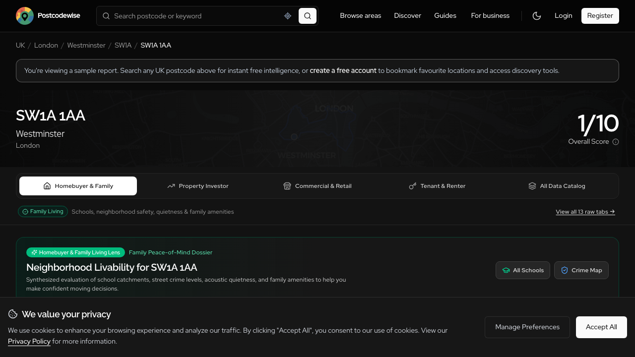
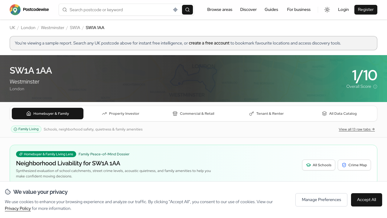
With Audience Lenses, we introduced four purpose-built analytical perspectives across every postcode, outcode district, ward, and comparison report:
1. Home Buyers & Families Lens
- Schools & Catchments: Nearest primary and secondary schools, Ofsted inspection grades (Outstanding, Good), and pupil progress scores.
- Safety & Peace of Mind: Violent crime frequencies, burglary rates, and anti-social behaviour trends.
- Green Spaces: Walking distance to public parks, playing fields, and recreational areas.
- Healthcare: Proximity to NHS GP surgeries, dental clinics, and accident & emergency hospitals.
2. Property Investors Lens
- Gross Rental Yield Benchmarks: Granular postcode yield percentiles compared against regional and national averages.
- Capital Growth Velocity: 1-year, 3-year, and 5-year Land Registry Price Paid trends.
- Tenant Demographics: Private renting ratios, median household disposable income, and economic activity.
- IMD Deprivation Deciles: Official Index of Multiple Deprivation rankings to identify gentrification corridors.
3. Commercial Operators & Retailers Lens
- Workforce & Footfall: Daytime working population vs residential night-time counts.
- Transport Connectivity: Station proximity, passenger interchange density, and bus connectivity.
- Commercial Planning: Live Class E commercial change-of-use and shopfront planning applications.
- Competitor Density: Saturation benchmarks within 500m, 1km, and 3km catchment radii.
4. Surveyors & Planners Lens
- Statutory Constraints: Conservation Areas, Listed Buildings (Grade I, II*, II), Article 4 Directions, and Green Belt boundaries.
- BGS Geotechnical Hazards: Shrink-swell clay subsidence, collapsible ground, and radon action levels.
- Defra Strategic Noise: Decibel contours for road, rail, and aviation corridors.
6. Deep Due Diligence: Defra Noise Maps & BGS Geohazards (v2.36)
Unseen physical and environmental factors can profoundly impact living conditions and property valuations. In v2.36, we integrated two critical datasets that protect our users from costly post-purchase surprises:
Defra Strategic Noise Contours
Under the Environmental Noise (England) Regulations, the Department for Environment, Food & Rural Affairs (Defra) models acoustic noise levels along major infrastructure:
- Road Traffic Noise: Motorways, dual carriageways, and busy A-roads.
- Rail Corridors: Passenger, high-speed, and freight lines.
- Aviation: Approach and departure flight paths around major airports.
We parse and render these official decibel bands directly on the map, exposing both Lden (24-hour weighted Day-Evening-Night indicator) and Lnight (nighttime noise between 23:00 and 07:00), giving buyers clear visibility into bedroom acoustic comfort.
British Geological Survey (BGS) Ground Stability
Foundation movement is one of the costliest property defects in the UK. We now display official BGS geohazard assessments:
- Shrink-Swell Clay Potential: Rated from Very Low to High. Essential for properties situated on London clay or Wealden strata.
- Compressible Ground & Landslides: Identifies peat beds, alluvial silts, and sloping strata prone to shear failure.
- Radon Gas Action Levels: UK Health Security Agency (UKHSA) radon risk maps indicating whether sub-floor protection is advised.
7. Next-Gen Planning Intelligence & District Outcodes (v2.34 – v2.35)
Understanding future development is critical when investing in property. In v2.35, we revamped our planning intelligence infrastructure:

Greater London Authority (GLA) Datahub Ingestion
For London postcodes, Postcodewise connects directly to the GLA Planning London Datahub—the statutory data registry for planning applications across all 32 London Boroughs and the City of London. Users receive live updates on residential developments, extensions, and commercial schemes complete with decision statuses and architectural descriptions.
Universal UK Statutory Council Planning Resolver
For postcodes outside London, Postcodewise automatically resolves the governing Local Planning Authority (LPA) from our local administrative hierarchy and delivers a verified deep-link directly to the council's official planning portal with pre-populated search queries.
Dedicated District Outcode Reports (/outcode/*)
Users evaluating broad geographical areas can now examine entire postal districts (e.g. SW1A, NW1, M1, EH1). Outcode reports bundle high-resolution GeoJSON boundary polygons with district-wide aggregates for sold prices, crime rates, school densities, and planning timelines.
8. Official Model Context Protocol (MCP) Server (v2.27 – v2.28)
Developers and analysts are increasingly automating research workflows using autonomous AI agents like Anthropic Claude Desktop, Cursor IDE, and custom orchestration pipelines.
To empower AI developers with verified location context, we launched the Official Postcodewise Model Context Protocol (MCP) Server:

Native Tools for AI Workflows
The MCP server exposes three core capabilities directly into your assistant's reasoning loop:
get_postcode_report: Retrieves a complete, verified location dossier (demographics, schools, crime series, environmental hazards, transport nodes) for any UK postcode.compare_areas: Performs side-by-side comparative analysis between two postcodes or postal districts with delta calculations on prices, safety, and amenities.find_areas: Discovers postcodes matching strict parameterized criteria (maximum price, minimum school rating, maximum crime rate).
60-Second Setup with Claude Desktop
Adding Postcodewise to Claude Desktop is as simple as adding three lines to your claude_desktop_config.json:
{
  "mcpServers": {
    "postcodewise": {
      "command": "npx",
      "args": ["-y", "@digitsflow/postcodewise-mcp"],
      "env": {
        "POSTCODEWISE_API_KEY": "YOUR_WORKSPACE_API_KEY"
      }
    }
  }
}
Now, when you prompt Claude: "Compare the top three postcodes in Manchester for rental yield and transport connectivity", Claude calls Postcodewise in real time to produce an accurate, hallucination-free report.
9. SiteScout Commercial Catchment Engine & Multi-Site Analysis (T17)
For commercial operators, retail franchises, and property scouts, evaluating potential retail sites requires synthesizing pedestrian accessibility, competitor saturation, and demographic spending power.
In Milestone T17, we enhanced SiteScout:
- 4-Quadrant SWOT Engine: Generates automated, data-grounded Strengths, Weaknesses, Opportunities, and Threats from real government metrics.
- Food Standards Agency (FSA) Premises Ratings: Direct integration of statutory food hygiene ratings, inspection dates, and local dining operator density.
- Multi-Site Comparison: Evaluate multiple potential commercial locations side-by-side against a shared benchmark.
10. Platform Speed, Security & Infrastructure Upgrades
Behind the scenes, we carried out substantial architectural upgrades to guarantee high performance, bank-grade security, and zero downtime:
1. Eliminating Third-Party API Bottlenecks
We completely removed live third-party runtime API calls (such as live Overpass or Open-Meteo requests) that previously introduced latency or rate-limit failures. Air quality data is now imported locally via Defra PCM, green space metrics are resolved from local OS Open Greenspace & National Forest Inventory (NFI) datasets, and all spatial lookups query optimized local indexes.
2. Multi-Factor Authentication & Passkeys
Security is paramount. We implemented Laravel Fortify Two-Factor Authentication (2FA) with TOTP authenticator apps and recovery codes, alongside Passkey (WebAuthn) and secure OAuth logins (Google, Apple).
Summary of Key Metrics & Technical Achievements
| Dimension | Before (June 2026) | Today (September 2026) |
|---|---|---|
| Search Autocomplete Latency | 300–400 ms | < 10 ms (Typesense SearchSense) |
| Transit Data Accuracy | Approximate / synthetic bus paths | 100% Official NaPTAN access nodes |
| Interactive Map Authoring | Static preview only | Full Map Studio with 3D extrusions & live geometry |
| Data Grounding & LLM Access | Web-only interface | In-Hero Conversational AI + Official MCP Server |
| Analytical Perspectives | Single monolithic view | 4 Audience Lenses across all report surfaces |
| Environmental Hazard Coverage | High-level overview | BGS Geohazards + Defra dBA Noise Contours |
| Planning Resolution | Fragmented searches | GLA Live Datahub + Universal 300+ LPA Resolver |
What’s Next?
Our summer release cycle has laid the foundational data architecture for the next era of Postcodewise. Over the coming months, we will be expanding:
- Advanced Multi-Site Portfolio Scoring: Automated ranking of hundreds of commercial locations simultaneously.
- Real-Time Planning Alerts: Direct email and webhook notifications whenever new planning applications are submitted within your target postcodes.
- Expanded Developer Webhooks & Streaming APIs: Enabling third-party proptech platforms to subscribe to location metric updates programmatically.
Try the New Features Today
Everything detailed in this update is live right now:
- Explore the new Map Studio to draw, measure, and style custom territory maps.
- Ask a neighbourhood question on our Homepage to test Conversational Location Intelligence.
- Search any UK postcode to explore Audience Lenses, Defra Noise Contours, and NaPTAN Transit Networks.
- Set up our MCP Server in Claude Desktop or Cursor to supercharge your AI workflows.
As always, if you have feedback, questions, or feature requests, reach out to our team at [email protected].
Postcodewise Product & Engineering
OfficialPostcodewise is operated by Digitsflow LTD, delivering verified open-government location intelligence, demographic insights, and spatial analytics across the United Kingdom.
Keep exploring
Recent Releases & Articles
Conversational Location Intelligence: Ask Any UK Postcode Question in Natural Language
Say goodbye to digging through dozens of disjointed data tables. With Postcodewise Conversational AI, you can ask complex questions about UK postcodes in plain English—from family suitability and school catchments to rental yield comparisons—and receive instant, verified answers grounded in official open government data.
Introducing Audience Lenses: Tailored Location Intelligence for Buyers, Investors, Businesses, and Surveyors
A family evaluating schools needs completely different insights than a buy-to-let investor assessing gross yields or a surveyor checking subsidence hazards. Introducing Audience Lenses: four purpose-built analytical perspectives available across Postcodes, Districts, Wards, Comparisons, and Guides.
Deep Due Diligence: Ingesting Defra Noise Maps, BGS Geohazards, and Postcode Rental Yields
What you cannot see during a ten-minute property viewing can cost you tens of thousands of pounds down the line. In Postcodewise v2.36, we have integrated official Defra noise mapping, British Geological Survey (BGS) geohazard assessments, and postcode rental yields directly into our reports.
Experience these features on your own postcode
Search any UK postcode to explore conversational location AI, school catchments, crime trends, planning applications, and ground hazards.